Showing posts with label weather. Show all posts

Tuesday, September 4, 2012

Here Comes the Rain - Part 2

It is official. Britain has had the wettest summer since 1912 according to the Meteorological Office. This follows one of the wettest springs on record. Is this evidence of climate change or simply natural variation in the weather?

To try answering this question, data from a weather station near Glasgow has been analysed . The first part of this article presented annual rainfall records and concluded that there has been only a slight increase in annual rainfall over the past decade compared with a baseline of 1961 to 1990 but that there had been a marked increase in variability. Also of interest is whether rainfall patterns have changed throughout the year, from month to month and between the seasons which is the subject of this post.

In order to provide some context, June 2012 was the wettest recorded June in 54 years with 130mm of rainfall which is almost double(196%) the average rainfall for the month and July is the fourth wettest with 75% more than average. Apart from this year, the five wettest Junes were followed by an average or below average July and likewise the five wettest Julies were preceded with a dry or average June. Data for August 2012 has yet to be published.

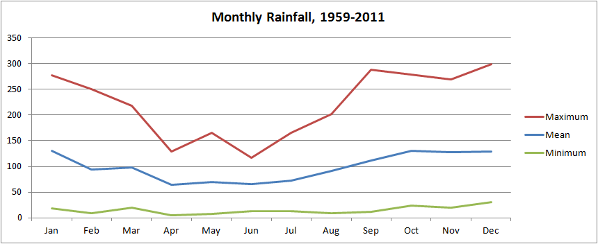
Over the fifty three complete years of data examined, there are wide variations in rainfall for each month as demonstrated by the monthly mean, maximum and minimum values plotted below. In some months the minimum values are almost zero while the maximum values may be almost three times the minimum.




Read more »

Monday, August 27, 2012

Here Comes the Rain - Part 1

Summer 2012 may be remembered for the Olympic Games. Or it may be remembered for the rain. From doom laden predictions of the worst drought for a generation in the southern half of Britain with disastrous consequences for farmers in the spring to torrential rain, floods and, yes, disastrous consequences for farmers in the summer.

The burning question is whether this is just the natural variability of weather or whether underlying climate change has a hand in driving these weather systems. To investigate this question, I have studied some local weather records. My statistical skills are about High School level: mean and standard deviation of a normal distribution.


Data for Glasgow Airport from 1959 to 2012 was obtained from the Meteorological Office website but the 2012 data was discarded as it is only provisional and represents an incomplete year. The data included monthly rainfall, sunshine and maximum and minimum temperatures and the focus of this study was the rainfall data.

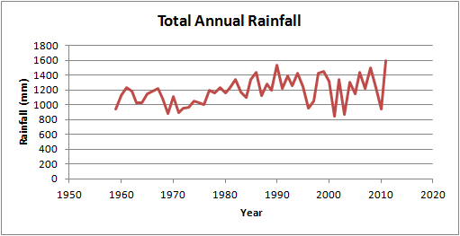
Annual rainfall figures are plotted below as a time series. The y-axis (rainfall) is drawn from zero to give a clearer picture of the relative changes; some graphs cut off the bottom which can visually exaggerate trends. Without performing any statistical analysis, the first impression is that annual rainfall has increased from the early 1970s to the mid 1990s before increasing again from around 2000 to the present time. The variability from year to year also appears to be greater in the more recent results, especially in the 2000s.


Read more »

Tuesday, January 3, 2012

When the Wind Blows

How the mighty have fallen -
Mature tree in Pollok Park destroyed
in December storms
It has been fairly windy in Scotland over the past year. Back in May, unseasonable storms battered the country causing one fatality, power outages, travel disruption, damage to crops and felling many trees.  We do not normally have such high winds during the spring and summer when the trees are in full leaf so they were more susceptible to damage and many mature trees were lost.

The next big storm was in September when the tail end of Hurricane Katia brought heavy rain, flooding and more trees down. It was not nearly as severe as Huricane Irene that struck the north east US a couple of weeks earlier but it still caused at least one fatality and significant disruption.

A relatively calm and mild but wet autumn followed as local government prepared for heavy snow like that which caught them out last year. Then came hurricane force winds on the 8th of December. They had been forecast a few days in advance with the Met Office issuing red alert and the authorities were taking no chances: closing most schools, recommending that people don't travel at all if possible and leave work early to avoid the most severe winds.  The main concern was that the strongest winds were forecast to occur during the afternoon and into the evening rush hour, meaning more people on the roads, hence a greater probability of accidents, people getting stuck and congestion preventing the emergency service getting about.  More trees came down as expected, knocking out power lines, closing roads and disrupting trains but the ferocity of the storms were perhaps a little less than expected.

December continued to be blustery with strong gales on Christmas Eve causing some localised damage (a neighbour lost part of his shed roof) then the next big one hit on the third of January.  This time central Scotland was hit hard as were parts of England and Wales.  The forecast was for strong winds but only an amber alert, rather than the red alert issued for the 8th of December storms so people didn't expect it to be as bad.

The damage was widespread and dramatic:
Read more »